Tokyo Shutoko Expressway
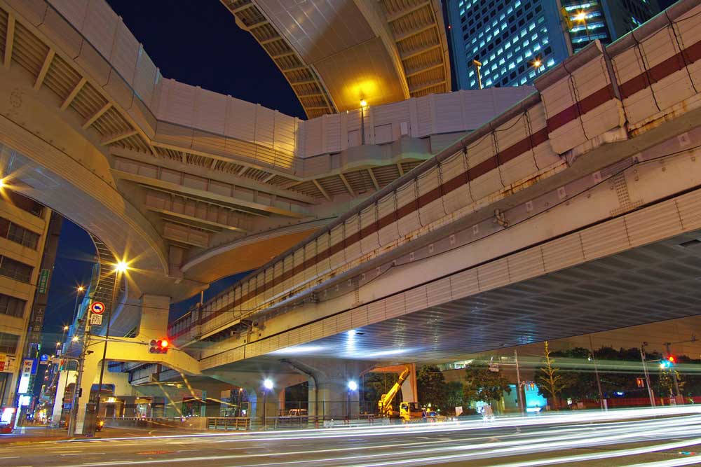
If you are living in or visiting Tokyo, you may at some point need to use the Shuto Expressway (首都高) or “Capital Expressway,” a network of roads that fly over the traffic on stilts or race under it through a warren of tunnels. It is a complex 327km network of sharp curves, on-ramps, off-ramps, and multi-lane merges that handles approximately one million vehicles every day. I have driven on it many times on my motorbike and have uttered more than a handful of expletives due to missing the correct off-ramp and adding another 20 minutes to my journey, so the following is as much for my benefit as anyone else’s.
What is the shutoko?
The Shuto Expressway is known as “shutoko” in Japanese. It refers to a vast network of expressways rather than a single road. Despite the name, this network extends into neighboring Saitama and Kanagawa prefectures. The heart of the system is the 14.8km Inner Circular Route (都心環状線), designated as C1, which loops past Tokyo Tower, the Imperial Palace, and much of Chuo Ward. The Central Circular Route (中央環状線), or C2, acts as the “Yamanote Line” of the expressway system, skirting the center of Tokyo and connecting to the Bayshore Route (湾岸線) near Odaiba. Other lines, such as the Ikebukuro Line and Meguro Line, serve as the arteries bringing traffic into and out of central Tokyo.
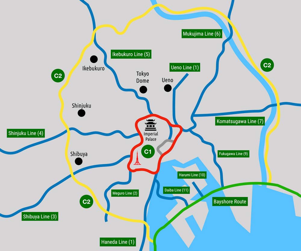
As you can see, these lines have specific names, but a numbering system is also employed to simplify navigation. The Inner Circular Route is C1, the Central Circular Route is C2, the Meguro Line is No. 2, and so on. All lines are operated by the Metropolitan Expressway Co., Ltd., so unlike the train network, you generally do not need to exit and re-enter toll gates when switching between these specific expressway lines.
Can’t I just use GPS navigation?
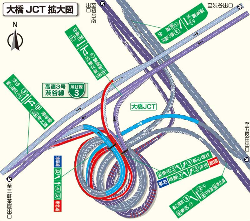
Yes, but with caution. The shutoko is often a narrow, two-lane “hamster tube” that swings constantly, requiring your full attention on the road. Relying entirely on a screen can be dangerous. Furthermore, a substantial portion of the network is underground—most notably the Yamate Tunnel on the C2, which at 18.2km is the longest road tunnel in Japan. GPS signals are frequently lost in these tunnels. While modern car navigation systems use gyro sensors to estimate your position, smartphone apps often struggle, leading to missed exits or junctions like the spiraling Ohashi JCT.
Moreover, because the shutoko often runs directly above surface streets, GPS can become confused, snapping your location to the road below. It is often only when the roads diverge that the navigation syncs back up and becomes reliable again.
How do I use the shutoko?
You enter and exit via junctions (JCT) and ramps. In central Tokyo, entrances are marked by green signs with the kanji 首都高 (shutoko). As of 2026, the system has moved heavily toward a cashless model. Many toll gates are now ETC-only. There are generally two ways to pay:
- ETC (Electronic Toll Collection): An automated system using a card and a vehicle-mounted reader. This allows you to pass through gates at 20km/h without stopping.
- Cash/Credit Card: Only available at “General” (一般, Ippan) gates, which are becoming increasingly rare.
Toll gates are color-coded: Purple for ETC-only, Green for Cash, and mixed for both. Drivers must take extra care to enter the correct lane, as stopping at an ETC-only gate without a card causes significant delays.
How do I get an ETC card?
Rental car companies usually offer ETC cards for a small fee. For residents, you typically apply for an ETC card through your credit card provider. You will also need a card reader installed in your vehicle. These cost between ¥6,000 and ¥15,000 for cars. For motorcycles, the units are more expensive (often ¥25,000+) because they must be waterproof and vibration-resistant.
How expensive is the shutoko?
Tolls are distance-based for ETC users. As of the current 2026 rates, the tolls for standard cars range from a minimum of ¥300 to a maximum of ¥1,950. If you pay with cash, you are automatically charged the maximum rate of ¥1,950 regardless of your exit. ETC users also enjoy significant discounts for late-night driving and weekend usage that do not apply to cash payments.
What are the speed limits?
The speed limit on most highways in Japan is 80–100 km/h. On the shutoko, however, only the Bayshore Route is 80 km/h. Most other sections are 60 km/h, with the Inner Circular Route (C1) further lowered to 50 km/h due to extremely sharp curves and short merge lanes.
What else do I need to know?
Motorcycles with pillion passengers are prohibited from most sections inside the Central Circular Route (C2). Pedestrians, bicycles, and motorcycles under 126cc are strictly prohibited from entering. Additionally, be aware that many exits and junctions on the shutoko are on the right-hand side, which can be unexpected for those used to standard left-side highway exits.